The Time Team programme on White Rock is online at https://www.youtube.com/watch?v=2Q0AP52z0gA and https://uktvplay.uktv.co.uk/shows/time-team/watch-online/5823203860001. Series 19, episode 6.
The programme report and abbreviated dig report are at Swansea Copperopolis and Swansea, a Copper-Bottomed Dig Report. The full report never surfaced.
The River Dock has given us clues to a pre-industrial society at White Rock.
This sketch of White Rock and the Smith’s Canal was made in 1797 by Thomas Rowlandson (1756 – 1827) on his one visit to Swansea during his Grand Tour. It was the subject of an article by Bernard Morris in issue 16 of The Swansea History Journal.
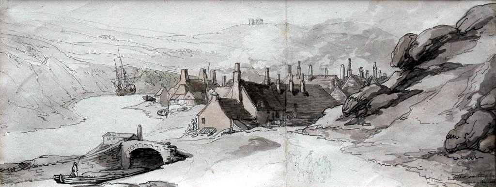
Thomas Rowlandson (1756-1827) ‘Copper smelting houses near Swansea’
The painting was sold at auction in 2007 for £8,400 (estimate £1,200 – £1,800). The buyer was unknown. The painting has now been acquired by the National Library of Wales, Aberystwyth. We hope it will soon be on display, and perhaps make a visit to Swansea and White Rock.
The Smith’s Canal has its source in Llansamlet. There is an interesting walk redolent of industrial archaeology – www.birchgrove.btck.co.uk/birchgrove%20history/coalminingtrail
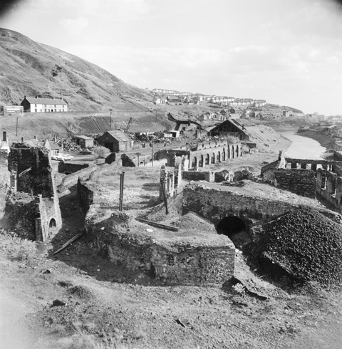
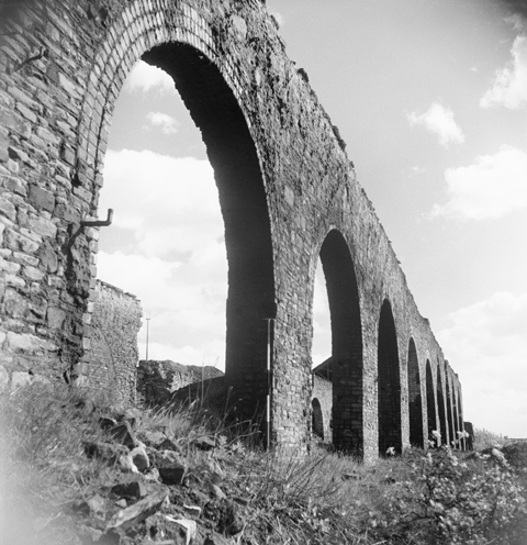
These photographs of the White Rock site in the 1960s are from the collection of the Royal Commission on the Ancient and Historical Monuments of Wales. The detailed interpretation is by White Rock team member Rob Hulme.
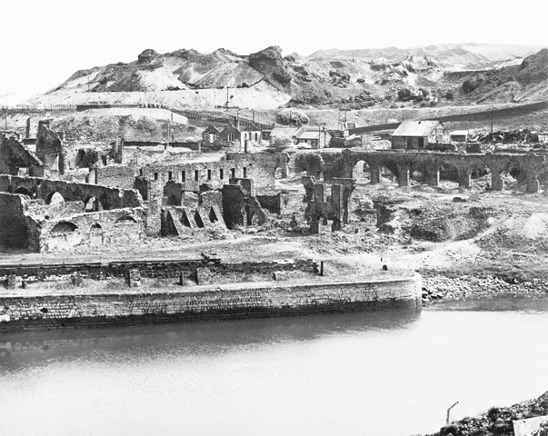
White Rock Site
White Rock site
View of the White Rock site taken from near what is now the hill next to the current car park. There is much of interest here. The tall structure in the middle left of the photo is close by the canal basin and formed part of the support for the railway incline and flue chimney which went up the side of Kilvey Hill. Only the lower section remains, which also contains an archway appearing to descent underground. Whether this was a kiln, furnace or part of the flue system is uncertain. Just across the pathway is the wall of a higher section which once carried a railway. Some of the four metal pillars which supported the incline at this point can still be seen. To the right of these is the start of the lower ramp of the incline. Under this is a brick archway which contains two bricked-up portals which lead directly to a chimney which is built into this part of the ramp.
Going across the centre of the photo from left to right are the entrance offices (partly obscured by the incline support structure, the masonry of which forms the northern portal of the canal tunnel and over which was one of the work’s main entrances). Looking carefully at the right hand wall of the pathway there is a notch where a railway bridge brought wagons into this section of the works. The ground appears to be the first floor of a building of unknown function, the external walls of which are visible beside the top of the ramp. On the right middle of the picture just below the river meandering into the distance are the remains of two further buildings which once contained furnaces.
Again traversing the photo a little further up are stores. The long arched structure was part of the ‘Great Workhouse’ which formed the main smelting hall of the original plant.
Finally, just above the centre of the photo are the entrance bridge over the railway coming up from Swansea St Thomas station, and one of the last buildings to be constructed on the site which is thought to have been a sheet lead plant. Towards the end of its life, the section from the stores to the lead sheet plant was apparently used as a scrap yard, the old railway loop and sidings being barely visible on later photos due to the piles of old vehicles and scrap.
Great Workhouse
Westward wall of the Great Workhouse
Westward wall of the ‘Great Workhouse’. This was one of the first buildings on the site, designated to hold over 20 copper reverberatory furnaces. It was the first such building to adopt a long and narrow format with the furnaces arranged primarily so that their grates were near the arches (good air supply) and their chimney flues central permitting better support from the high roof.
Incline Support Tower
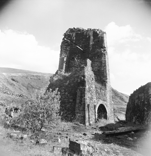
Incline support tower
The incline support tower with its enigmatic archway in the base. The archway forms what appears to be either a hearth or flue exit. It has been suggested that it was once a blast furnace or a lime kiln. However, it was built at the time of the incline itself and how it could have functioned as such is very much open to conjecture given its location relative to other adjacent structures.
Brick Archways

Brick archways
The exterior west wall of one of the buildings nearer to the river and just to the north of the excavated river dock. Note also the brick archway which appears to have been given a ‘first floor’ connection to the adjacent building. The main building has probably fulfilled a number of roles in its life. In the early days, this part of the plant was dedicated to water-powered production of furnace linings. However, later illustrations show it as a roasting or smelting furnace house, while other documentation suggests further use as a brass annealing house and later even a lead pipe plant. This goes to show just how usage of the plant changed regularly over its 200 year history. It also shows that the White Rock works was not just another copper smelter. It has been used for the production of silver and gold as well as lead and possibly brass. The brick buttresses are of note, cropping up regularly around the site.
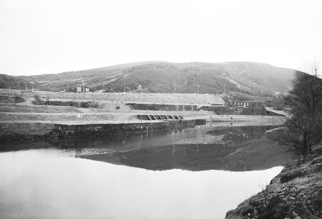
Slag Tips

Slag tips
View of the slag tips to the north of the works site. The old copper smelting process produced a lot of iron-rich slag, which was initially just dumped. A sizeable section of the White Rock site itself is probably build on such slag heaps as the section near to the river was basically marshland. (The level of the quays is now a good 2 metres above the river level). However, the land soon became dry and plants grew wherever they could, including on the mountainside behind the smelter works. In later years it was realised that so long as the slag wasn’t contaminated with poisonous chemicals it could be successfully used as landfill for roads. The track visible on the photo was probably there to allow trucks access to collect slag for such a purpose.
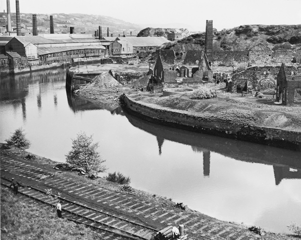
South of White Rock
Southern end of site
View of the southern end of the site following the land clearance taken from the towpath of the Hafod Works. Visible are the old quayside adjacent to the excavated river dock, and running across the middle of the photo the back wall of what was once the Great Workhouse – the main smelting hall of the early works. This was built adjacent to the canal so that the coal could be off-loaded directly into the smelting hall. To avoid access problems, the canal at this point was covered over to make a tunnel. Boats gained access to the Great Workhouse by portals built into the side of the tunnel, some of which are still extant.
View from Hafod
View from Hafod
View of the old site looking across the river from where the remains of the Vivian Engine Shed is today. On the river is one of the wooden-clad quayside structures. Just in front of the slag tip in the right middle of the picture is the one remaining wall of what was once part of the Vivian’s silver and lead processing plant. It was constructed around the start of the 1870’s, at the same time as the incline and flue system up Kilvey Hill. It is thought that the building on the right hand bank of the river was a boiler house (with its square plan chimney) and pump house. The other buildings on the right hand middle of the photo eventually formed what may have been the lead pipe works.
Copper Works
General view of the copper works
General view of the Copper works part of the White Rock site. Just above the river quay walls are the two buildings which have been suggested as being brass annealing plant, although in earlier days probably were either roasting or smelting houses. Another smelting house is located above these and forms the masonry remains which currently lie to the south of the top of the ramp. The wall of the Great Workhouse – the main smelting hall – crosses the right middle of the photo. Just to the left of centre are the two buildings which formed the Gatehouse Offices while above the Great Workhouse wall and located above the location of the canal tunnel are the railway sidings and yard. The main building here appears to be a later prefabricated structure either related to the lead sheet production plant or the later scrap yard. The massive copper slag tips are a prominent feature of the skyline at this time. They are now greatly reduced and covered in vegetation.
White Rock 1744

White Rock 1744 (Thomas Lightfoot)
Thomas Lightfoot’s famous engraving of White Rock in the earlier years of its existence. Note the marshland/field by the river (complete with cow) and the early slag mounds which eventually reclaimed the marshland by the river. The old millpond and mill are visible to the left of the works. The Great Calciner building is located at the centre of the engraving while just a little lower and stretching almost the length of the works is the Great Workhouse. The buildings nearer the river were additional calcining and smelting furnaces, while to the right is the extant dock and the Mansell coal yard. The ‘Great Coal Road’ – an early horse drawn tramway – ran down the valley from the local mines past the mill and just to the north of the Great Workhouse, and ended in a coal tipping tower by the river at the southern end of the site.
All the photographs are:
© Crown copyright: Royal Commission on the Ancient and Historical Monuments of Wales
© Hawlfraint y Goron: Comisiwn Brenhinol Henebion Cymru
There are some interesting images of Swansea, including the Tawe and the Lower Swansea Valley, at www.swanseapictorialhistory.co.uk
The Rowlandson was bought by Lowell Libson Ltd and exhibited by them, British Watercolours Autumn 2014, #18 Thomas Rowlandson, ‘The White Rock Copper Works, Swansea’ [see website] and now sold again.
I understand the picture has been bought by the National Library of Wales. I don’t know if it on display yet. Lowell Libson’s catalogue for the Autumn 2014 sale is at http://www.lowell-libson.com/downloads/files/Lowell_Libson_Ltd_-_British_watercolours_-_pdf_version.pdf
Great site and explanation of the fascinating history. What would really help to bring the 1960s pictures to life would be a ‘then and now’ comparison?
Hello Dan,
There are some images of White Rock when it was derelict – just before, during and after the 1960’s clearance. Most of these are on our website. There are very few, if any, of the copper works at White Rock, Hafod-Morfa, or indeed any others during their heyday. We would be delighted to find photographs or any other images. We have scoured the archives without success so far.
We have a good collection of maps and site diagrams over two hundred years from which we can recreate images of the works. We need the help of an artist to bring this to life – offers welcomed!
John
Thank you for this website and the work you do on the site itself. As children in the late 70s and early 80s, white rock and the other derelict areas were, to us, just a massive playground – a fascinating mix of forest, derelict buildings and slags tips, silent and separate from the bustl,e of the city around us, and we thoroughly enjoyed playing there. We were even perhaps the last users of the section of the canal there, as back then it was still permanently full of water even in summer – though very overgrown – and we used large polystyrene floats scavenged from nearby factories to float on the canal have mock ‘sea battles’. I was amused at the safety precautions being taken during the filming of ‘Time Team’ because of the various chemicals and poisons undoubtedly there; we spent HUGE amounts of time there over some years, rooting around the ground, getting dirty as kids do and getting soaked with canal water, yet we were fit as fiddles and all are to this day. Obviously, the whole area was an eyesore and had to go, but looking back we were very lucky to have been the last generation as kids to have had it as a wild playground- it was cleared away very shortly after that and three years later I was a young army reserve soldier at the then brand new Morfa TA Centre built just the other side of the river as part of the redevelopment.